It is always easy to arrange a fast road trip from Bangalore because of its ideal location and topography. The silicon valley in India's Bangalore region offers a range of possibilities to satiate various leisure demands, from magnificent waterfalls to spotless hill stations and peaceful beaches.
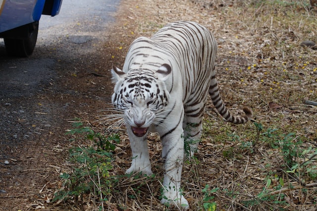
A lot of rare and endangered creatures, including the tiger, lion, bison, leopard, and wild boar, may be found at Bannerghatta National Park, a well-known national park in the Indian state of Karnataka. Because it serves as a crucial corridor for elephant migration from the Eastern Ghats to the Western Ghats, Bannerghatta National Park has also been able to grab the interest of animal enthusiasts. The park was established in 1971 and was accorded national park status in 1974. In 2002, a section of the park transformed to become the Bannerghatta Biological Park, a biological reserve. The park is especially distinctive in that it houses an aquarium, a snake house, a safari park, a zoo, a butterfly enclosure, a butterfly enclosure, a zoo, and a full-fledged animal rescue center. Since its beginnings, the rescue center has saved the lives of several wild animals, particularly those from circuses.
The park lies 22 km to the south of Bangalore and has an elevation range of 1245 m to 1634 m. Three types of vegetation, including Southern Tropical Dry Deciduous Forests, Southern Tropical Moist Mixed Forests, and Dry Deciduous Scrub Forests, can be found in the mountainous topography. On the perimeter of the park, there are 16 communities. Elephant migration is made easier by a river that connects the Sathyamangalam forest and BR Hills, which is a component of the wildlife corridor.
The Suvarnamukhi stream, which provides the majority of the park's animals with water, starts at the Suvarnamukhi hills, which span a distance of more than a kilometer. Nearly two kilometers away from the hills is the Suvarnamukhi, whose water is reputed to have healing properties. Additionally, four bore wells have been built this year in the park to complement the natural water supplies and address emergencies.
Bangalore City is not far from Manchanabele Dam, which is accessible at a distance of 50 kilometers. Large water storage provided by the dam offers an improved opportunity for migratory birds. Even though this dam's surroundings aren't particularly lovely or appealing, the location nonetheless has a certain allure. Although the drinking water supply for the Bangalore district's urban region is allotted to this dam, it does not serve any hydroelectric power generation or irrigation management purposes.
This dam's history of construction is favorable. It is thought that the water that gathers in this dam is Maharshi Durvasa's perspiration. He spent a considerable amount of time here for meditation on his trip to South India. But the saint found it difficult to stray in the area's geography. He was experiencing excruciating leg pain, making it challenging for him to ascend the hill to engage in "Dhyanam." In any case, he scaled the hill, where he meditated before Lord Vishnu appeared in response to his adoration. When Lord Vishnu noticed the saint's perspiring physique, he waved his hands in the direction of 3600 people, blessed them, and then vanished. Additionally, he moved his hands down and instructed the soil to take the form of a bowl to hold the great saint's perspiration. Since that time, the lower portion of the hills has taken on the appearance of a reservoir, and the neighboring hills' water supply is regarded as Maharshi Durvasa's perspiration. Later, Maharshi Durvasa blessed the neighborhood since a nearby Banyan tree shaded the saint during his summertime wanderings. A vast Banyan tree orchard is currently located 9 kilometers from this dam, and the oldest tree in this region is thought to be 350–400 years old.
Since no hydroelectric power production project is associated with this dam, no sizable technical investment has been made here. However, canals have been started from this dam to irrigate the valuable agricultural land nearby.
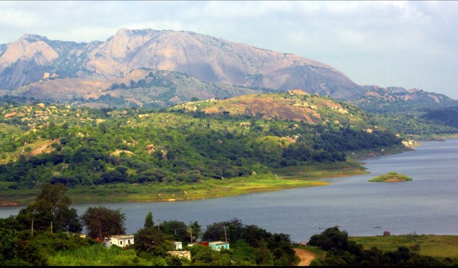
Even if the actual location is not extremely gorgeous and lovely, the surrounding region of this dam is full of attractions, and the presence of so many tourists attests to the area's value. A freshwater lake, also known as BTM Lake, offers a superior vantage position from which to see migrating birds. Here, spotting the Spot-billed Pelicans is a top draw. This migratory bird made this area it is home for practically the whole year. Other bird species have also made the lake their home. Given that they are the biggest monoliths on the Asian continent, Savan Durga Hills is a popular tourist destination. The area is also well-known for its hiking opportunities. The backwater of the dam also offers a visitor a calm and laid-back attitude, which may explain why this location is the most popular despite the lack of superior beautiful sites. There is also a sizable Banyan tree here. The tree is said to be more than 350 years old. One of the most stunning features of the place is the rural Indian landscape that surrounds the dam. This location is great for weekend getaways because of the laid-back ambiance that is a specific tool for making visitors feel at ease.
The Pearl Valley sometimes referred to as Muthyala Maduvu, is a lovely picnic area outside of Bengaluru. This tourist attraction is approximately 40 kilometers (km) from Bengaluru and 5 kilometers (km) from Anekal.
This naturally beautiful location is a fantastic retreat from Bengaluru's bustling city life. As its name indicates, Pearl Valley is located in a valley tucked between lovely hills. For those of you seeking a day off from the hectic routines in Bengaluru, this is the perfect picnic location.
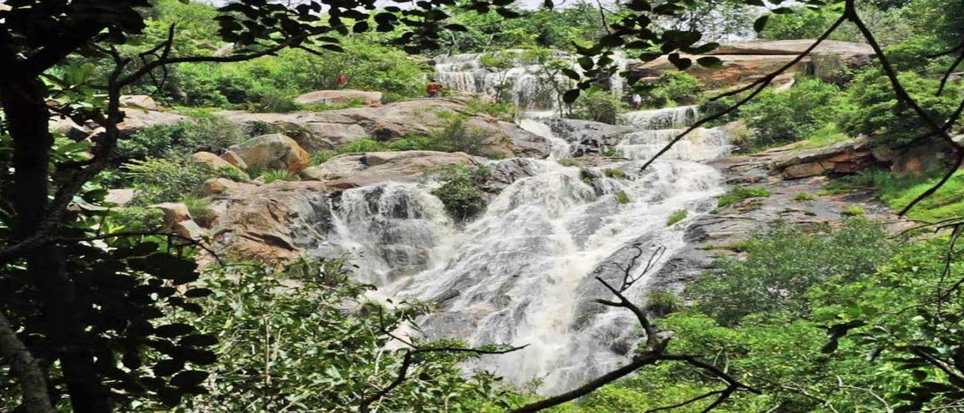
The captivating waterfalls that are the major draw of Pearl Valley, also known as Muthyala Maduvu, are surrounded by a stunning mountain range. In Pearl Valley, the main waterfall is a flowing torrent that plunges from a height of 92 meters. Onakanahalli, a neighboring tank, is where the waterfall got its start. The vegetation in this area is wetted by the river, which gives the effect of strings of pearls. The name Pearl Valley comes from the way that water from the fall is dispersed across the surface of the rocks, giving the impression of scattered pearls. You can find great peace in the babbling rivers that surge through the rocks.
Ramanagara is located 50 KM away from Bangalore city. It was once known as a "Closet." Later, it was given the new name Ramanagara, which was taken from the nearby Ramagiri hill. Ramanagara, made up of the Taluks of Ramanagara, Channapatna, Magadi, and Kanakapura, was recently created from the Bangalore Rural District. Bangalore Urban District and Tamilnadu in the East, Tumkur District in the West, and Bangalore Urban District and Mandya District in the North, all of which border the district.
The District features both steep and flat terrain, as well as flora and fauna. Granites, which date to the lower proterozoic age, are a prominent topographical feature of this area. Ramanagara District has an overall geographic area of 3516 square kilometers, of which 699.46 square kilometers are covered in forest, and 823 settlements. The three rivers that pass through the district are the Cauvery, Arkavathi, and Kanva. The District's primary crops include commercial ones like groundnut, mango, mulberry, toor dal (togari bele), coconut, and cocoon production.
Mulberry, silk weaving, milk, and toys are popular in the Ramanagara District. Ramanagara is known as the "Silk City" because it is home to one of India's largest silk markets. The Channapatna area of Karnataka is known as "Toys City" because it is home to many industries that produce wooden toys that are well-known for their exquisite carvings and paintings. The Ramanagara District has an industrial area that houses well-known and large industries like Toyota, Coca-Cola, Bosch, etc. 'Magadi Kempegowda' has a long history in Magadi. The Arkavathi River, a tributary of the Cauvery, enters the Cauvery near Sangam, which is located in the Kanakapura Taluk. In this location, pilgrims take a sacred bath in the hopes that it will cleanse their karma.
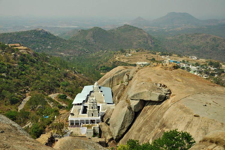
The Ramadevara Betta Hill near Ramanagara, which lies distant from Bangalore's concrete jungle, is one of the most popular tourist destinations. The hill, which is perched 3,000 feet above sea level, provides stunning views of the abundant natural world.
The Bollywood movie "Sholay" was filmed here, and the surrounding hills are just out of this world, which contributes to this location's popularity. This is the greatest option for you if you're looking to escape in a soulful way.
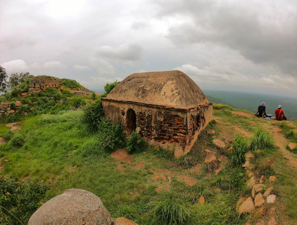
Is a hill fort next to the same-named settlement. It is located 10 kilometers beyond Doddaballapura on the road to Gauribidanur, 60 kilometers north of Bangalore. A historic Shiva temple with Nandi is located in the fort at the top, and Markandeya Rishi is said to have conducted penance here. Near Ghati Subramanya, a well-known pilgrimage site, Makalidurga Fort is perched on a sizable granite mound in a valley formed by a chain of hills. At a height of 1,117 meters, it contains a fort on top. It is becoming a popular hiking location for thrill seekers. Many people go here at night to hike. Makalidurga is a hill fort located next to the village of Makali in Karnataka, at a distance of 6.4 km from Ghati Subramanya Temple, 18 km from Doddaballapura, and 61 km from Bangalore City Junction. One of the best things to do in Bangalore is this.
The height of Makalidurga Hill above sea level is 1350 meters. It was once a grain storage facility for the Palegar "Makaliraya" in the late 1800s. As a result, it is called Makalidurga. A temple to Lord Krishna is located at the foot of the hill. Lemon grass, date bushes, and tiny pebbles cover this slope. The views of the lakes on each side, the winding roads, and the railroad track below the hill are all quite picturesque from the hilltop. It's thrilling to catch sight of the train from here.
The Makalidurga Trip is a somewhat challenging trek. On the rock, some written instructions detail how to climb. Although this path is not as well-known as Savandurga's, the experience is nevertheless fantastic. The major draw of Makalidurga is the Fort, which is perched on a sizable granite hill. A historic Shiva temple with Nandi is located in the fort at the top, and Markandeya Rishi is said to have conducted penance here. Trekkers from different locations frequently travel the rough, difficult routes that make up the journey to the fort.
Makalidurga's history states that during the Vijayanagara Empire, military drills were held here. Shahaji (the father of Shivaji) later took control of the location following.
Kempe Gowda took control of the Vijayanagara Empire after seizing it from Shahaji. In Makalidurga, night hiking is a fantastic experience. The hike takes around two hours, so hikers may start at ten in the evening, a camp for a time at the top of the hill, and then descend by five in the morning. A qualified guide is essential for the Makalidurga night walk, and hikers should also bring a flashlight, bug spray, enough food, and drink. It is highly suggested for those who are traveling to Makalidurga for a day trip to bring their food and drink. The greatest time to hike in Makalidurga is from September to February.
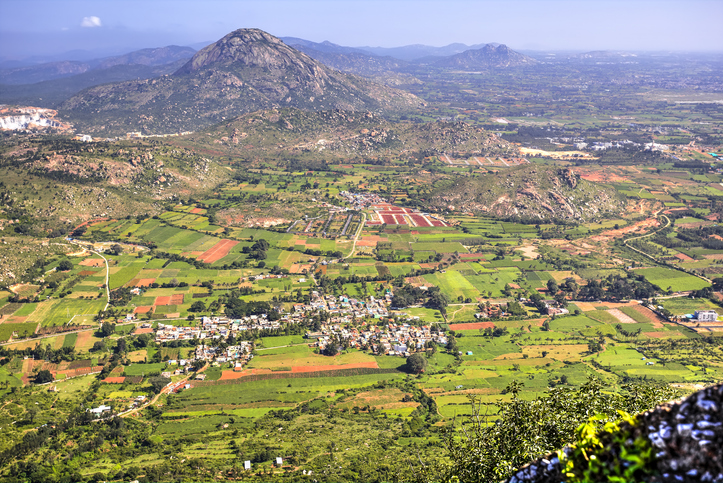
An old hill fort named Nandi Hills, often called Nandidurg or Nandi Betta, is located in the Karnataka district of Chikkabalapur. The Arkavathy River is said to have its beginnings there, and they are said to be close to the town of Nandi.
The hills received their alleged name from the nearby ancient Dravidian temple that was devoted to the Nandi figure. The name's genesis is, however, the subject of several legends. The hills were known as Ananda Giri, or "The Hill of Happiness," during the Chola Period. Some claim that Yoga Nandeeshwara did his penance here, which is why the hills have his name. Additionally, it is said that the hill's likeness to a sleeping bull is how the Nandi Hills got their name (Nandi).
Nandi Hills, which is 4851 meters above sea level, is a beloved vacation area for all nature enthusiasts and a well-liked location for picnics. Nandi Hills is the perfect escape if you enjoy shooting pictures, admiring nature's beauty, and being touched by the breathtaking vistas Mother Nature has provided for us. The hills are the ideal location for a vacation since they provide stunning landscapes, unusual vegetation, cold fresh air, and quiet.
Early mornings are the greatest time to take in this picturesque location's charm. Even though you may go to the hills at any time of the year, it is advised that you go while it is raining.
Through private-public cooperation, Nandi Hills is now undergoing a multi-crore makeover, including a one-crore refurbishment of the Tipu Fort, to convert the hills into a tourism hotspot. At a cost of around one crore, the Department of Horticulture is building a food court in the hill station that will be fashioned after one in Singapore.

Skandagiri is renowned for its stunning dawn under rising clouds and somewhat challenging night walk.
Skandgiri is a gorgeous weekend retreat that also doubles as an adventurous weekend escape. It is located 3 kilometers from Chikballapur hamlet. It is a hill where there are the remains of an old fort from the 18th century. The walk to the summit of the mountain is nonetheless enjoyable despite the fort's crumbling state and that of the nearby temple.
Bangalore is not far from Skandagir. A trip to Skandagiri and back, including the ascent, may be completed in a day and a half. Regular buses go between Bangalore and Skandagiri. You must take a bus from Bangalore to Chikballapur to arrive at Skandagiri. There are two methods to go to Skandagiri hill's base from Chikballapur. You may either walk to the base or take a car, which takes approximately 15 minutes. It takes approximately an hour to walk to the base, but you get to see rural life and beautiful scenery along the way.
The path is signposted, making the ascent of Skandagiri quite simple. In terms of vegetation, the first section of the walk is very barren. However, you begin to notice rich foliage as you approach the hill's summit. The valley below may be seen in all directions from the hill's summit. You almost feel like a monarch yourself when standing there on top of the hill, keeping an eye on your realm. Soak a stroll around the fort to take in the mystique even if it is in terrible shape. At the top of the slope, there is a pool of water as well. However, due to reckless hikers using it as a trash can, there is now practically any water in the pool.
Even while climbing Skandagiri is a fantastic experience year-round, winter is the greatest time to accomplish it. The summit of the hill is frequently shrouded in mist throughout the winter, which makes for a truly lovely experience.
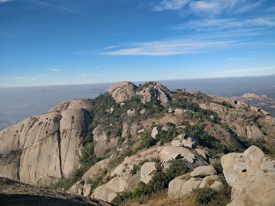
The twin hills are known as Karigudda and Biligudda, which respectively mean "black hill" and "white hill," and are where the Savandurga Fort is located. The Savandurga hills are around 35 kilometers to the west of Bangalore. The hills, which are a part of the Deccan plateau, are one of India's largest monoliths.
The Savandurga hills were inhabited by some sort of human settlement around 2000 years ago. Recently, terracotta pots, copper coins, and megalithic burial urns containing bones were discovered at the site.
The hills are first mentioned in documents belonging to Hoysala Ballala III in AD 1340, where they are referred to as Savandi. The Imperial Gazetteer of India states that Samantha Raya, an official in the Vijayanagar Empire, constructed this fort for the first time in 1543. The Magadi area and the fort were conquered by the Bangalore chief in about 1570. The region served as the secondary administrative center for the Magadi kings, particularly Kempegowda.
Mysore captured the fort in 1728. The jail at the fort was situated among the hills during the reign of Hyder Ali. It was rumored that jailbreak was not conceivable. As a result, the fort earned the moniker Savina Durga, which translates to "the fort of death."Another legend about the fort is that, in the 18th century, Bangalore could see the fort, but it was inaccessible because of the lack of steps going up to it. The hill was covered with bamboo and other plants, effectively creating a barrier and contributing to the "fort of death" moniker.
The fort was taken by Lord Cornwallis in 1791, however, it was afterward abandoned. As a result, there isn't much of the fort remaining; the nearby forest has taken over what's left.
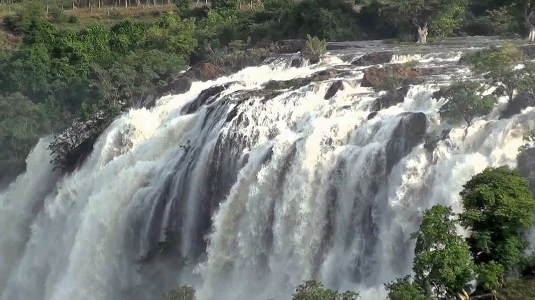
Bangalore metropolis brims with natural splendor, as seen by the Chunchi Falls' vibrant showers. It is a common day-trip destination in Kanakapura Taluk, 90 kilometers from Bangalore City. The river Arkavati is crossed by this waterfall. This charming location is surrounded by beautiful, green woodlands. Chunchi is a little settlement made composed of only a few dwellings.
At Sangama, the stream runs and joins the Kavery. During the wet season, the falls will be breathtaking to watch. Similar to Kanakapura, the temperature will be usually 28 degrees Celsius.On the banks of the Arkavati River, the Chunchi waterfall is tucked away among the breathtaking ranges of cliffs. It is located between Sangam and Yelehalli. The granite troughs are sliced through by the waterfall's rippling gleams. It's breathtaking to see Chunchi Falls from above. Chunchi Falls, while being a little one, charms tourists with the beauty of its cascading cascades of water in a lush environment. On the major Mysore-Hassan route, get off at Krishnarajanagar to go to the waterfall.
Since Chuncha and Chunchi, a tribal couple, hosted the Lord Sri Ram throughout his vanvas, Chunchanakatte is revered as a sacred location. The sound of the thunderous falls can be heard anywhere here, except for the inner sanctuary of the old temple, which is why this place is significant. According to mythology, Lord Ram was weary of Seetha's constant whining and cursed that a woman's tongue shouldn't be sharp and that because the Kavery River is regarded as a woman, whatever disruption the stream caused wouldn't be heard in the sanctuary of the lord.
As Sita grew weary and considered taking a bath, Lord Ram instructed Lakshman to shoot an arrow at a rock. When Lakshman let go of the arrow, water began to spew out in three different colors: one with oil, one with shikakai, and one with turmeric.Even now, when there is a sizable amount of water gushing torrentially down the falls, these hues are still discernible. Before the power plant was built here, the area was like a paradise on earth with the best of nature. Farmers and employees of a nearby sugar mill and, more recently, a power plant are the primary populations in this area.
In Karnataka, Devarayanadurga is situated not far from Tumkur district. In keeping with its name, "Devarayanadurga," which is appropriately translated as "Fort of the God," Despite having several previous titles, it was given the name Devarayanadurga after Mysore monarch Chikka Devaraja Wodeyar conquered it.
The area is almost 4000 feet above sea level and is a good weekend getaway for a retreat or picnic to get away from the grind of everyday city life's hustle and bustle. Due to the numerous hillocks that surround it, it is also a trekker's heaven. Numerous wildlife enthusiasts visit the location for different wildlife shootings and other activities. The forest department of the Government of Karnataka has designated it as a reserved forest for protection.
Because it is so close to Tumkur city and district, as well as Bangalore's IT area, the population swells on weekends and holidays.
Devarayanadurga has a rich legendary history. The universe's creator, Lord Brahma, is claimed to have engaged in penance for several thousand years in Lord Vishnu's honor. Lord Vishnu has taken on the form of Lord Narasimha in this location after being moved by his penance.As one reaches the entrance of the temple grounds, one may still feel the sacred water flowing through the Yoga Narasimha statue, which is described in several legendary literatures as being a highly sacred spot.
The temple or fort is constructed in Dravidian architecture, and it is estimated that the temples date back roughly 2000 years. The temple, which was renowned for its exceptional sculpture, benefited greatly from the wealthy sponsorship of the Chola Kings. In this location, there are two temples dedicated to the Hindu deity Narasimha, one of which is located at the base of a hilltop named Bhoga Narasimha and the other of which is situated atop Yoga Narasimha.
We provide major services such as: Apartments | Plots | Automotive | Electronics Repair | Restaurants/Fast Foods | Health Care / Doctors | Advocates/Legal Consultants | Architects/Interior Designers | Industrial Products | Computer Repairs and IT Services | Other | and much more.
Octal Space provides a variety of services to help you expand your reach and connect with millions of shoppers, whether you're a major company, a small business, or a marketing agency. We provide a successful lead-generating approach and a marketing strategy that is ROI-oriented.

Ooty Tamil Nadu India
Call Us 9600255874
support@octalspace.com